Background:
GPR DATA LLC was contacted to perform a geophysical ground penetrating radar survey on a rural area in Lane County Oregon, Sweet Creek Road. The site area needed slide repair and been the location of road base failure over a long period of time. Numerous additional asphalt lifts have been added and applied to the road surface to correct the deformations. The specific location of failure borders a vertical up hill embankment with a near 5 to 1 slope. The down slope embankment continues to the creek some 30 feet below. The bed rock or base rock formation is a brown hard sandstone mixture. This information compiled from a well soil log performed by others for Lane County in the survey grid. The soil log will be used as a ground proof point for depth and identifying geologic soil layers as they exist in the strata.
The critical objective of this report is to establish the angle of the bedrock slope formation at depth as it relates to the road surface over the length and width of the GPR survey.
Findings:
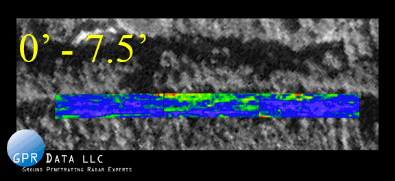
After processing and analyzing the positive average amplitude GPR response at various depth slices, 0.0 to 7.5 feet, 7.5 to 10.0 feet, 10.0 to 12.5feet, 12.5 to 15.0 feet, 15.0 to 17.5 feet, 17.5 to 20.0 feet, and finally 20.0 to 24.0 feet depth slice interval maps were selected as most representative. This interval series of 2.5 feet was utilized because it closely demonstrated the slope as a function of depth. The color scale on each map indicates the signal amplitude strength at the indicated depth interval. Violet to dark red coloration indicates areas of relatively stronger reflection amplitudes. The quantitative numbers in the scale, 0 to 9000 at 500 point intervals reveal the change in amplitude with depth. The colors graduate with the stronger reflective signal values as the soil geology changes from fill to bedrock, (hard brown sand stone).