GPR Concrete Imaging
GPR Data is a leading expert in GPR Concrete Scanning and Imaging.
Contact us today to schedule a demonstration, presentation, or 3D scan on your project.
GPR concrete imaging provides the information you need to continue safely with your project. Not only does GPR concrete imaging help ensure your team and structure will be safe, its effectiveness guarantees the project won’t be slowed down due to costly accidents.
Concrete X-Ray or
GPR Concrete Imaging?

Benefits of GPR Concrete Scanning & Imaging
- Reduces the safety risk to the public and site workers
- Reduce liability and cost (should you cut into a post tension cable, conduit, or utility)
- Saves time
- Gives you the information needed to ensure a successful project
Call for a Quote:
1-541-345-1075
As-Built Documentation/As-Build Drafting
GPR Data pioneered “as-built verification” and “as-build drafting.” This type of GPR concrete imaging is ideal for historic or older buildings that lack as-build information and need updating for current building codes, seismic safety updates, or the restoration of a historic building.
When GPR Data performs as-built verification and drafting, we give our clients:
- High-resolution imaging and 3D maps
- 2D or 3D AutoCAD drawings and image reports that are easy to understand and use as needed
Check out how we helped Union Station in Portland; a great project we did with “as-built verification” and “as-build drafting.”
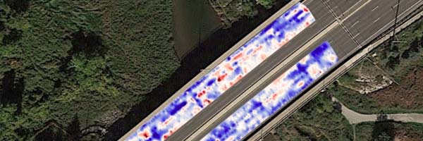
Deterioration, Settlement Voiding, Delaminations Detection
When we’re looking for deterioration, settlement voiding, or delamination detection, GPR concrete and earth scanning provides high-quality 3D maps. This helps assist in evaluating the scope of the remediation project.
Post Tensioned Cables
GPR Data can provide thorough post tension cable imaging. Whether the post-tension cables are banded, bundled, or with uniform layouts – we find what you need and provide you with a thorough 3D image and (x, y, z) positioning report.
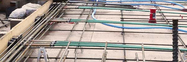
Rebar Mapping
When your engineers and architects need help with structural evaluations or design/build services, GPR Data can help. We provide a comprehensive report of findings that you can use throughout the project.
Contact Us
![]()
![]()
![]()
![]()
Portland, Oregon (Corporate Office)
Eugene, Oregon
Phone: 541-345-1075
Fax: 541-684-7865
2645 Suzanne Way, Eugene, OR 97408
Medford, Oregon
Phone: 541-228-6851
Seattle, Washington
Phone: 541-228-6851
1216 SE 5th St, Battle Ground, WA 98604
Las Vegas, Nevada
Phone: 702-240-3046
8220 Ducharme St, Las Vegas, NV 89145
Los Angeles, California
Phone: 310-678-2088
14937 Sherman Way, Van Nuys, CA 91405
Fairbanks, Alaska
Phone: 907-978-0187
1045 Kuskokwim Way, Fairbanks, AK 99775