The purpose of this field investigation was to use non destructive ground penetrating microwave radar to three dimensionally image a roadway subsurface spanning an area 500’ long by 34’ wide. Upon completion of the field imaging, each GPMR data was post processed then analyzed to determine the existence of subsidence, erosion voiding, or loss of stability beneath the roadway and shoulder.
Silica based soils and rock such as sandstone store and return electromagnetic energy extremely well. A logarithmic digital processing code was written based upon these silica rich conditions and fill soils conductivity. This processing code was designed to filter and clean the GPMR data to produce the clearest images possible depicting the sub‐grade fill soils characteristics and bedding properties.
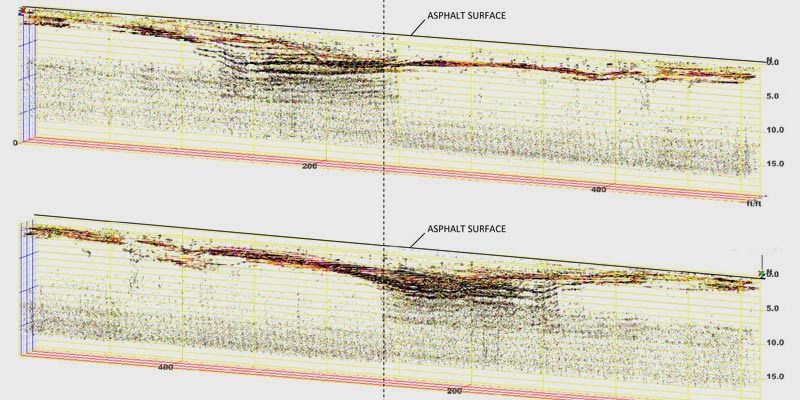
 Excerpt: Findings of GPMR & Field Data Test Results
Multiple factors are contributing to the deformation and continued subsidence seen beneath this section of roadway. Water runoff and infiltration, local geology, poor quality fill soils, and highly erosive layers of dipping bedrock are creating a circumstance that allows fill soils to migrate. Large volumes of water seep into the soils of the open fields above the west side of the road. The top soils allow water to migrate within toward the west embankment and the swale overgrown with pine trees. Heavy water runoff down the west side of the road ditch line has also saturated and infiltrated the fill soils, specifically in the areas between angled layers of dipping bedrock.
Poor quality porous fill soils have allowed water infiltration into these areas resulting in soil swelling and piping through the down slope east embankment. Weak acids created by water and sandstone are accelerating the erosion in these areas. Inadequate runoff control is contributing to this condition by allowing water to saturate and seep into fill soils on the west embankment. We have determined some of the drainage culverts to be positioned in a way that water runoff would need to be 2.0’ in depth at the west ditch line in order to drain out the east side of the roadway embankment. Soil movement overtime has caused some of the culverts to shift out of place rendering them incapable of channeling water through to the east side of the road. Most of the water runoff down the west ditch line seeps into the fill soils and below the road base then slowly migrates down slope.
There are two main areas of concern to report from the GPMR data. One very large sinkhole that originates at a depth below 30.00’ and one smaller area of subsidence that terminates at a depth of 12.00’. The characterization for each area corresponds directly to the GPMR data presentation section of this report. This information and presentation should be used to design and implement a long term approach of fixing the problematic circumstances created by this setting.