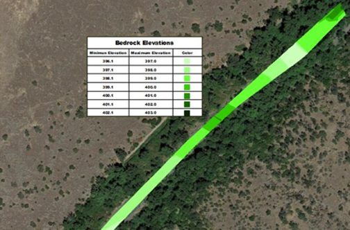
Background: Northwest Hydraulic Consultants were planning improvements and possibly deepening of the Paynes Creek Diversion Dam area. The area had already had a topography survey but they also needed information about what the area looked like below the ground. Particularly they needed to know the elevations of the bedrock throughout the area as this would have the biggest cost impact on any improvements.
GPR Data’s Solution: GPR Data spent a day scanning the difficult terrain with a high resolution antenna coupled with GPS. Paring the GPS data to the GPR data allowed for mapping of georeferenced bedrock depth throughout the area. The subsurface bedrock map was laid over the existing topographic survey to give project managers a full view of all available options.
Learn more about Bedrock Mapping